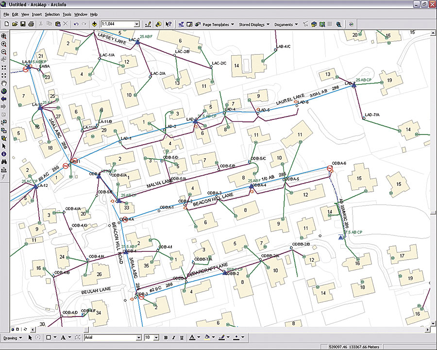
WIRELINE COMMUNICATIONS
GIS for planning, design, and management of next generation networks
The telecommunications sector has witnessed significant technological and regulatory changes over the last two decades. The concept of the converged or unified network for voice, data and video information has greatly influenced the industry leading to a trend of migration of copper network to fiber.
Geosilicon provides domain specific GIS solutions that address the entire telecom industry landscape including cable and broadband services. Our key capabilities include copper and FTTx design, drafting and migration services using CAD, GIS and SpatialNET technologies.
These are complimented with our strong application development capabilities for enterprise application integration, technology up-gradation / migration, and developing smart tools for conflation, network migration, and automating critical processes and workflows.
Geosilicon has successfully developed solutions for complex telecom projects for a range of global clients. Our solutions enable clients to achieve operational efficiencies, capacity optimization, and required throughputs. We have experience on all leading industry platforms such as Synchronoss SpatialNET, Intergraph FRAMME, Ericsson Network Engineer, and other Custom OSP applications.
Solutions
Network Planning and Design (Fiber and Copper)
Geosilicon offers network planning and design services for FTTH, FTTC &FTTX, GPON technologies to communication service providers across the globe. Our team of network planning & design experts synthesize their domain knowledge with technical capabilities to provide efficient design solutions which optimize the client’s existing infrastructure and enable faster network rollouts. We also offer trained domain experts to help our clients increase their network capacity, thereby enabling improved customer experience.
GIS Data Management
Geosilicon has considerable experience of developing and maintaining high quality datasets for for both OSP (Outside Plant) and ISP(Inside Plant) networks. These datasets are developed using best of the breed industry technologies and processes that ensures reliable network information for various business and operational support systems. Key services include:
Application Development
Geosilicon provides a host of innovative solutions using industry-standard tools and platforms for the communications industry to maintain accurate, up-to-date data for planning, design and management of networks. Our dedicated team of application development experts provides the following services:
WIRELESS COMMUNICATIONS
Largest repository of geo-data products of most recent vintage
In today’s competitive landscape, the wireless telecom industry faces multiple challenges including optimizing infrastructure costs, improving customer experience, and coping with the rapid transition of technology. We at GSTPL, provide geo-data solutions that help the industry address these key challenges.
Gosilicon is the world’s leading supplier of geo-data for fixed wireless (WLL, LMDS) and mobile wireless (GSM, CDMA, TDMA, UMTS and WiMAX) networks. Our solutions help clients in wireless network planning, design and performance optimization. Our solutions include DEM/DTM, Land Use/Clutter, Vector/Linear databases, 3-D building heights and off-the-shelf geo-data products, at varying levels of details, resolution and accuracy.
Geosilicon has varied experience of developing simple desktop viewer applications to large, scalable and secure web-enabled systems for enterprise and public portals.
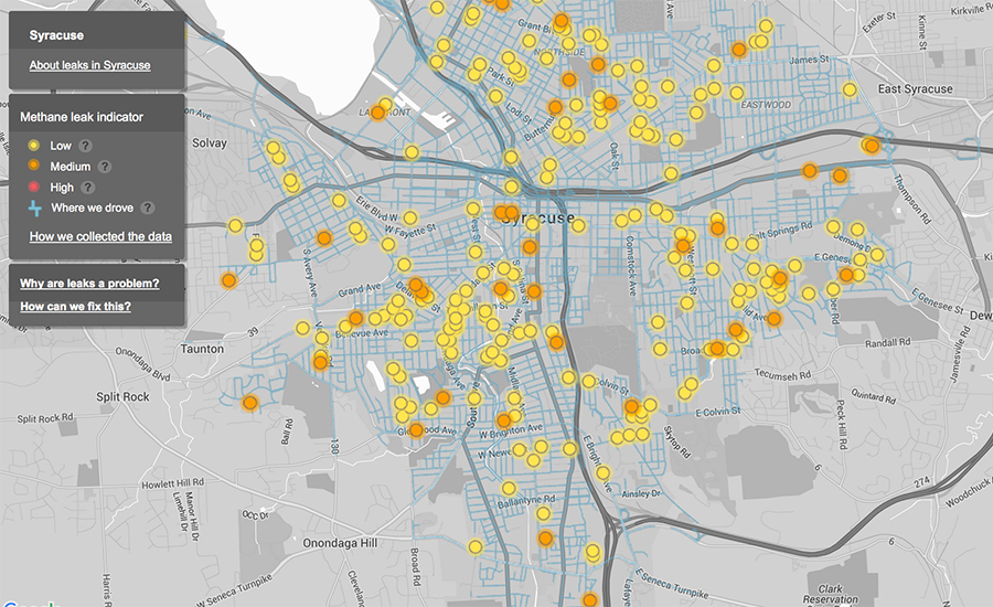
GAS
GIS managed services for distribution integrity management
Geosilicon provides domain specific enterprise GIS solutions that seamlessly integrate with other systems to increase process efficiencies and streamline information flows across the business value chain. We partner with clients to help them meet their key challenges of improving operational efficiencies, reducing operations costs, improving asset management, optimizing capacity, mitigating risks and meeting regulatory compliance requirements.
Geosilicon ’s key differentiator lies in its unique ability to automate processes, develop customized tools, and workflow management systems that help reduce the total cost of ownership and delivery time, while maintaining the highest levels of quality.
Solutions
Network Management
Geosilicon helps gas utilities to optimize network infrastructure investments by supporting their planners with efficient engineering drafting services to meet municipal regulations for permit approvals. We also ensure maintenance of asset network in GIS and Enterprise Asset Management systems in accordance with real world changes. Our smart network management solutions help our clients in improving the reliability, integrity and traceability of their networks. Key services include:
Asset Data Management
Geosilicon develops high quality, cost effective data management solutions using the industry best breed of technologies and process innovations for managing assets. Our solutions are specifically tailored to our customer’s needs and help them face the challenges of handling their ever growing assets, infrastructure and diverse business processes. Key services include:
Distribution Integrity Management
Geosilicon supports utilities to meet various integrity management programs by capturing critical information about each asset from base maps, planners sketches, engineering designs,field notes, leak cards, customer service tickets, as-built work orders. This helps in tracking of every bit of information about the asset, hence ensuring safety and reliability to its customers. Our services include:
Enterprise GIS
Geosilicon develops custom applications to seamlessly integrate existing geospatial data and applications with other enterprise systems, optimizing operational workflows thereby enhancing performance and service reliability. RMSI also supports complex projects by developing smart in-house tools to enhance productivity and efficiency and ensure maximum quality compliance. Key solutions include:
Big Data & Analytics
Geosilicon business domain expertise coupled with rich technical competencies enables us to define Big Data strategies for the utility sector. Key services include:
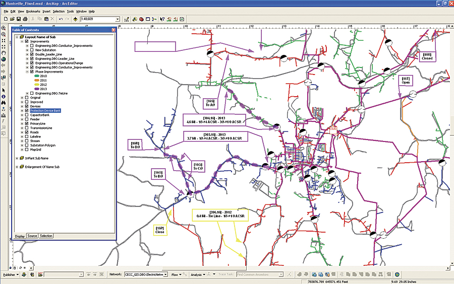
ELECTRICAL
Integrated GIS for managing transmission and distribution networks
Geosilicon helps utilities to design, store, manage, and maintain network information to operate distribution infrastructure safely, efficiently, and profitably using integrated CAD and GIS tools, with the best of the breed technologies
Our comprehensive GIS solution offerings include consulting & ideation, to actual implementation & post implementation support. Our solutions span the entire value chain from records conversion and management, to supporting critical engineering and business applications for electric transmission and distribution networks.
Geosilicon key value proposition is its unique ability to synthesize strong domain knowledge with technical abilities. Our solutions are backed by proven expertise in consulting, analysis, design and implementation of enterprise solutions. Our technology agnostic approach allows us to implement solutions grounds up or take over existing investments in technology by our clients.
Solutions
Asset Data Management
Geosilicon develops high quality, cost effective data management solutions using the industry best breed of technologies and process innovations for managing assets. Our solutions are specifically tailored to our customer’s needs and help them face the challenges of handling their ever growing assets, infrastructure and diverse business processes. Key services include:
Network Management
Geosilicon leverages its unique ability of sythesizing domain knowledge with technical capabilities to provide focused solutions in network management. Our solutions help our clients in improving the reliability, integrity and traceability of their networks.
Enterprise GIS
Geosilicon develops custom applications to seamlessly integrate existing geospatial data with other business & operational support systems. We help our clients in optimizing their operational workflows thereby enhancing performance and service reliability. In case of complex projects, we specialize in developing smart in-house tools to enhance productivity, efficiency and achieve maximum quality compliance.